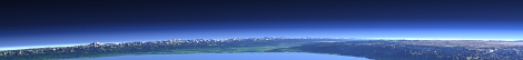

Severnaya Zemlya map

Severnaya Zemlya is a group of islands in the Russian Arctic forming the northmost part of Asia. These were the last major islands discovered in 1913 and are still one of the least explored areas on Earth. Like Franz Josef Land they are poorly covered in most web map services.
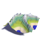
The map you can find here is mostly based on satellite images from the last 4 years. The relief data is older so there are significant mismatches is some parts. The satellite images layer is a mosaic created from the same Landsat images the mapping is based on. Most of the map data (except for the vegetation and relief) is available in Openstreetmap.
More details can be found in this blog post.
Using data from:
USGS,
viewfinderpanoramas.org

Visitor comments:
no comments yet.
By submitting your comment you agree to the privacy policy and agree to the information you provide (except for the email address) to be published on this website.