

Evaluation of the ALOS AW3D30 relief data set
As part of my long term series on reviewing global open data relief data sources this review discusses the
![]() ALOS AW3D30 Global Digital Surface Model recently released
by the Japanese space agency JAXA.
ALOS AW3D30 Global Digital Surface Model recently released
by the Japanese space agency JAXA.
Context for this data set
If you today are looking for open relief data on a global level there are essentially three well known sources available:
- SRTM (my review here) - the veteran of open relief data.
 Jonathan's viewfinderpanoramas.org elevation data - supplementing the SRTM data for truly global coverage.
- The ASTER GDEM data set (my review here) - latest version released 2011.
All of these have their limitations - like in terms of age of the data, accuracy, quality variations and resolution. Most other global sources are either not open data or are further processed derivatives of the above. There are of course meanwhile a lot of local data sets available under open data conditions but these are of generally varying standards and therefore difficult to use in combination and coverage based on such local sources is still a patchwork limited to those countries where the political landscape has allowed open data policies to gain foothold.
So additional global sources are always welcome and in early summer this year JAXA released something interesting along these lines.
About the data set
The ALOS AW3D30 Global Digital Surface Model is - like ASTER GDEM - created through stereo-photogrammetry. The main difference is that the ALOS PRISM instrument was specifically designed for this purpose while for ASTER stereo imaging is only a secondary application. Imaging resolution is 2.5m and the original raw 3d surface data generated from this is 5m resolution which is ![]() commercially available. The data set now released as open data is a reduced version.
commercially available. The data set now released as open data is a reduced version.
The ALOS satellite failed in 2011 and the successor, ALOS-2, does not have the optical camera systems of ALOS - so there will not be updates to this data set in the future using additional imagery. With the satellite started in 2006 on average the data is probably from around 2009.
The terms of use/license conditions are fairly similar to those of ASTER GDEM and fairly simple - there is no warranty of any kind and you have to credit the source whenever you use the data.
To access the data you have to ![]() register on the JAXA website. What you get when you have done that is packages of 5×5 degrees containing single degree individual files similar to SRTM and GDEM. The most significant difference to SRTM is that the tiles are edge aligned as it is common for imagery data and not pixel center aligned. This might lead to problems when integrating this data into established processing workflows.
register on the JAXA website. What you get when you have done that is packages of 5×5 degrees containing single degree individual files similar to SRTM and GDEM. The most significant difference to SRTM is that the tiles are edge aligned as it is common for imagery data and not pixel center aligned. This might lead to problems when integrating this data into established processing workflows.
Overall download volume for the global data is more than 250GB. This is partly because the packages contain two different versions of the data. One represents the median of the higher resolution data points, the other the average. The difference is fairly subtle but can for example be observed in the following area which shows a solar power plant in southern Spain.

|

|
| Average sampling | Median sampling |
Some of the original data points are on ground level, some are on top of the structures. So the average leads to an intermediate elevation while the median alternates between those levels.
Elevation values are integer meters which is all right since the noise levels are sufficient to avoid discretization artefacts. For each 1×1 degree tile five files are provided for both the average and the median version: The elevation data set, a mask image indicating gaps and water areas and an image showing the number of source images the data is based on - all of these as GeoTIFF files - and two metadata text files.
Coverage
Since the data is produced with the same methods as ASTER GDEM it also suffers from the same fundamental problems and limitations:
- When clouds obscure the ground no measurement is possible so areas with frequent and persistent cloud cover are difficult to observe.
- Since stereo-photogrammetry is based on structure matching between different images areas with featureless optical appearence (like snow or other flat and uniformly colored surfaces) and surfaces with fast changes between the image acquisitions (i.e. water) cannot be properly measured.
As a result of this the ALOS elevation data contains different kinds of gaps in the measured data
- Data voids where no elevation data is determined (dark).
- Inland water areas and other areas of unreliable measurement which have been filled with constant elevation values (dark gray).
- Ocean areas set to zero elevation (brighter gray).

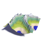
|
| ALOS AW3D30 coverage - the colors indicate the number of images forming the data basis - green means more images, red less |
The first two types of gap account for about 19 percent of the land area data points (compared to less then 1 percent of voids in SRTM). As you can see in the coverage map large parts of these gaps are located at polar latitudes in Greenland and the Antarctic but there are also significant gaps in the tropics and at intermediate latitudes. There is also significant variation globally in terms of image recording frequencies so quality levels are not exclusively based on natural factors like surface appearance and cloud cover. There are also a few tiles missing for unknown reasons in northern Greenland and Canada. Completely missing as well are many Russian Arctic islands as well as various remote islands in the Atlantic and Pacific.
Particularly well covered are Australia, large parts of the Middle East and Central Asia, the western US and western Mexico and the ice free parts of northern Greenland. Limit of the data is slightly above 82 degrees latitude.
Data quality
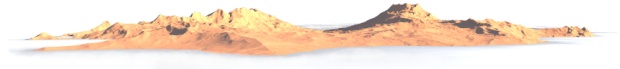
So far things look pretty bleak about this data with the high incidence of gaps. But looking at the data itself between the gaps things look quite good acutally. As primary sample area for evaluation i chose the Sierra Nevada in southern Spain. This is a fairly friendly area, little cloud cover and ground with generally structured coloring, only little water. Here are some sample 3d renderings of this area in comparison to other data sets:

|

|
| ALOS AW3D30 | |

|

|
| SRTM1 | |

|

|
| ASTER GDEM | |

|

|
| IGN/CNIG MDT05 resampled to 1 arc second grid | |
As you can see resolution and noise levels look pretty good and there are no obvious artefacts visible. The data has the same nominal grid resolution as SRTM 1 arc second data but while for SRTM the actual resolution is around 50m the ALOS data is resampled from a much higher resolution grid so resolution wise it is close to the best you can expect from a 1 arc second grid. Per pixel noise levels are comparable to SRTM 3 arc second data so significantly better than SRTM 1 arc second and much better than ASTER GDEM.
Compared to the locally acquired IGN/CNIG reference data there is some horizontal offset visible in the difference image:

|
| Difference to IGN/CNIG reference - negative in blue and positive in red |
The exact causes for this are not quite clear to me - would need to be verified in other areas.
Of course not for all parts of the world the data looks quite as good. Here another sample area from the northern Ural mountains in Russia.

|
| ALOS AW3D30 artefacts - data gaps marked in red |
These kind of pit and spike artefacts are common, especially in the neighborhood of cloud gaps. They are probably caused by faulty cloud masking.
The other main problem with the data is the filling of water surfaces and other areas with insufficient signal. This is mostly unusable and should be treated just like data gaps for most applications. Here an example of Lake Brienz.

|
| ALOS AW3D30 water flattening errors |
The elevation level assigned to the lake is about seven meters above the actual water level so the lake would spill out into the valley on both sides. In addition at the western end the flattened area does not match the actual water extent - not a big error here but elsewhere this is frequently much larger. As a result the flattened elevation values in these areas with a mask value of 2 are best treated like data gaps with a mask value of 1.
Here another example from the Norway coast - including both ocean water areas flattened to non-zero height and shadows filled incorrectly leading to artificial cliffs.

|
")
|
| Fill/flattening errors | Fill/flattening errors (with mask) |
Summary
The ALOS elevation data provides a very useful addition to the open data elevation information available globally. It offers a more recent data basis than SRTM as well as generally higher quality of the data in most parts. This is hampered for practical use by the significant extent of data gaps and fill data of questionable use. This means for most practical applications the data will only be useful through significant processing and combination with other data sources.
Christoph Hormann, August 2016
Bibliography
The JAXA download site for the data set lists two publications describing the data and its properties. These are written by the producers of the data set so they do not provide a neutral point of view of course. I am not aware of any independent evaluations so far.
Visitor comments:
no comments yet.
By submitting your comment you agree to the privacy policy and agree to the information you provide (except for the email address) to be published on this website.